2025.01.07
From Disaster Prevention/Mitigation to New Businesses! Advanced Applications of Artificial Satellites Set to Take off in Outer Space
Mitsubishi Electric Corporation was responsible for the development and manufacturing of Advanced Land Observing Satellite "DAICHI-4" as the prime manufacturer*1. A state-of-the-art onboard radar "PALSAR-3" enables the observation of an area four times as wide as before, and also increases observation frequency five-fold. Leveraging these advantages, observation satellites are expected to be used for extended purposes from the assessment of disaster severity and the formulation of restoration plans to the evaluation of corporate environmental, social and governance (ESG) activities. Mitsubishi Electric has been involved in artificial satellites for a long time. Utilizing its experience and technologies in this field, the company has launched a new solution business specializing in satellite observation. It will formulate disaster prevention schemes in cooperation with relevant public offices, other industries, and start-ups, with the aim of developing new businesses.
- 1 Prime manufacturer: Manufacturer in charge of integrated processes for an artificial satellite from design to manufacturing, testing, and preparations for a launch.
Contents
Speed and Efficiency Required on the Sites of Damage Assessments
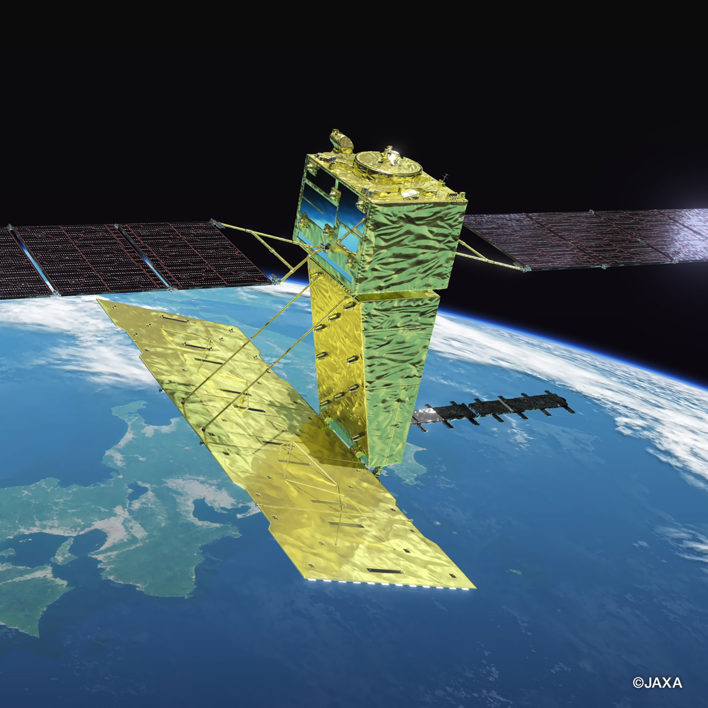
On January 20, 2024, Japan’s unmanned probe "Smart Lander for Investigating Moon (SLIM)" (prime manufacturer: Mitsubishi Electric Corporation) successfully performed pinpoint landing on the Moon’s surface, a world first. Furthermore, under the Artemis program, a Moon exploration program led by the US, which was outlined on April 11, a Japanese astronaut will walk on the Moon. Against these backdrops, interest in space development never ceases to increase. High hopes are pinned on the Advanced Land Observing Satellite "DAICHI-4 (ALOS-4*2)" that is due to be launched on June 30, 2024. (Later, it would be successfully launched on July 1.) Ahead of the planned launch, the spacecraft was unveiled on March 11 at Mitsubishi Electric’s Kamakura Works.
- 2 ALOS-4: Advanced Land Observing Satellite-4
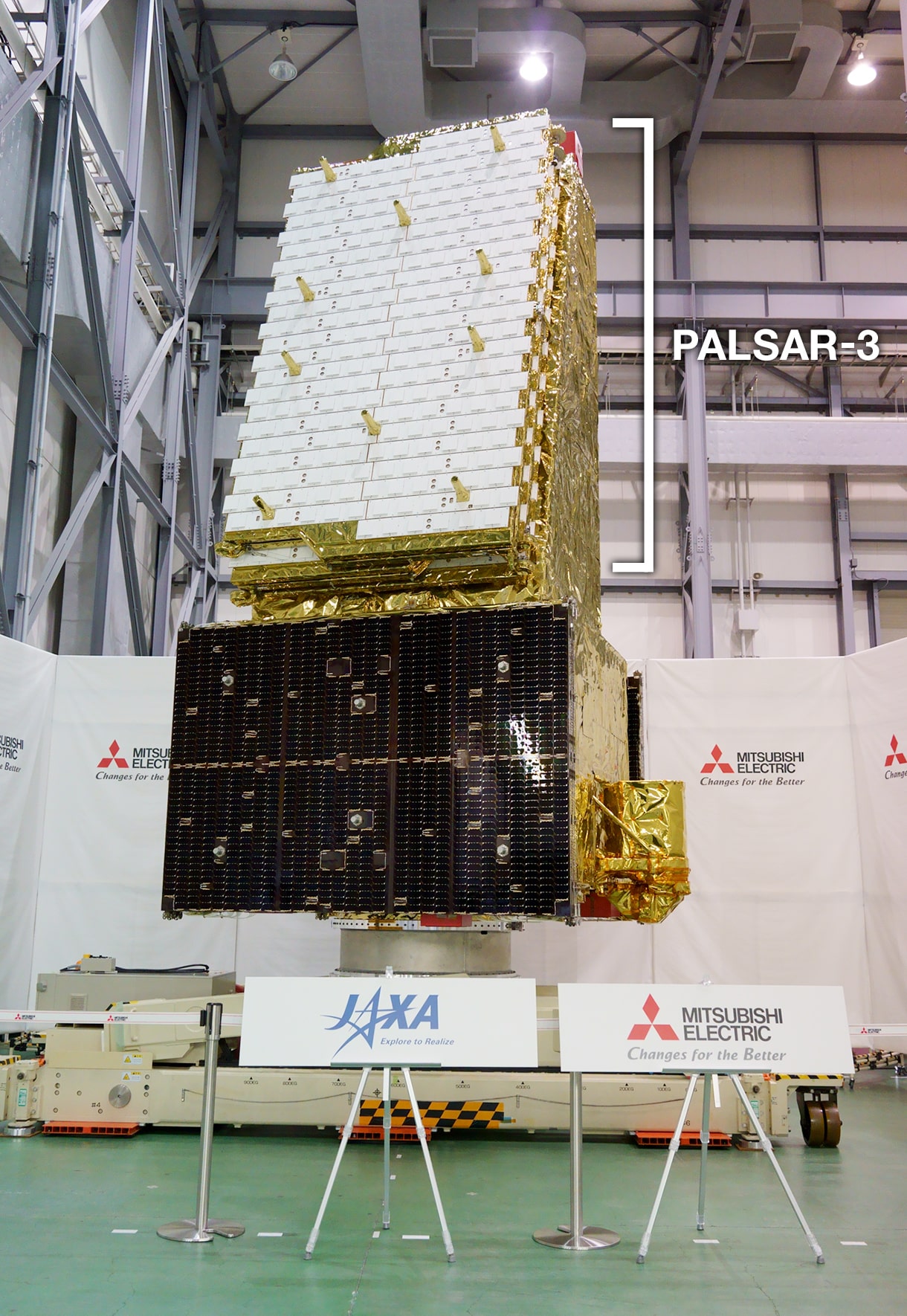
When the solar panels attached to the satellite spread out like black wings (shown in the lower part of the photo), the spacecraft measures about 20 meters wide. It weighs approximately three tons, of which core part is the built-in radar "PALSAR-3" (shown in the upper part of the photo).
PALSAR-3 will spread on the orbit into 3.6 meters high and about 10 meters long. Ahead of the launch, the radar is folded up compactly to be stored in the third H3 rocket. What is going to happen when this radar opens up in space and starts observing the Earth? We interviewed two people involved in the development of ALOS-4 and Mitsubishi Electric’s observation satellite solutions business.
Five-fold Increase in Observation Frequency Enables Early Detection of Ground Transformation
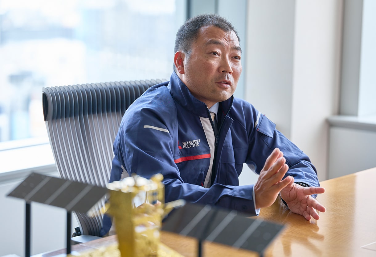
Takehiko Sagara, Deputy Senior General Manager of the Space Business Development Center in Mitsubishi Electric’s Space Systems Division, expresses his hopes on the eve of the launch, "ALOS-4 is a satellite with superb capabilities. I hope that it will demonstrate them in space. I can only hope for the successful launch now." He had a yearning desire to work at Mitsubishi Electric’s space division with passion for things working in space. Since he joined Mitsubishi Electric, Sagara has dedicated his career to the development of artificial satellites.
 Takehiko Sagara
Deputy General Manager
Space Business Development Department
Space Systems Division
Mitsubishi Electric Corporation
Sagara: ALOS-4 has an onboard radar called "phased array type L-band synthetic aperture radar," or commonly known as "PALSAR-3." ALOS-2 (DAICHI-2), which is currently in operation in space, also has the same type of radar onboard. However, PALSAR-3’s performance is much better than that of ALOS-2’s radar. For instance, ALOS-2’s observation width (or a swath, a range that a radar can observe at one time) was 50km in high resolution, while ALOS-4 has an observation swath four times as wide as that of ALOS-2. In other words, ALOS-4 is capable of observing an area more than 200km wide at once.
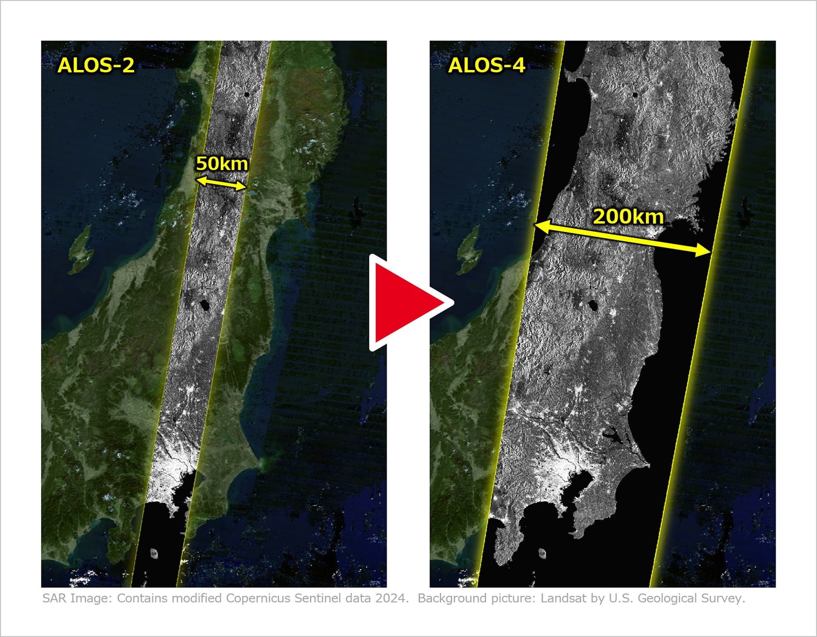
ALOS-2’s observation swath is 50km in high resolution, which means that it takes about 56 days for it to observe throughout Japan and can supply observation data for entire Japan no more than four times a year. On the other hand, it only takes 14 days for ALOS-4, which has a significantly enhanced swath of 200km, to observe all over Japan. As a result, ALOS-4 can supply observation data for entire Japan as many as 20 times a year.
Daisuke Sango has been engaged in research & development of synthetic aperture radars (SARs) for more than 20 years since he was a student, and is currently working at the Image Solution Systems Section of Mitsubishi Electric’s Space Integrated Systems Division. He explains how ALOS-4 can be utilized in the future.
 Daisuke Sango
Group Leader
Image Solution Systems Section
Space Systems Department
Kamakura Works, Mitsubishi Electric Corporation
Sango: A SAR satellite like ALOS-4 can observe a specific location swiftly, even when it is away from Japan, by adjusting the direction of emitting radar waves. For example, when a large earthquake hit the Noto Peninsula at 16:10 on the New Year’s Day in 2024, ALOS-2 successfully observed the affected area before midnight on January 2, eight hours after the quake. In the future, when similar disasters occur, ALOS-4 may be able to provide high-definition images even more quickly. I am sure that this will help assess the degrees of damages quickly and deliver necessary aids where needed fast.
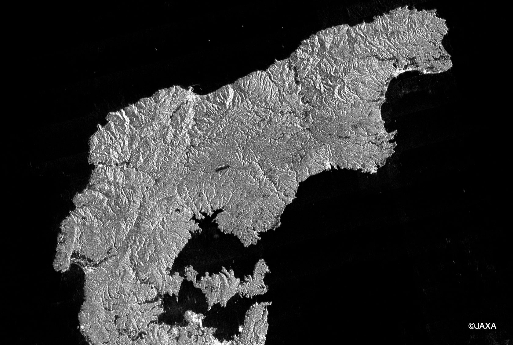 An observation image of the Noto Peninsula captured by ALOS-2. The satellite was ready to perform emergency observation just three and half hours after the quake. Radar satellites are capable of observing even in the darkness of the night or on cloudy days. Despite having begun after the sun set, ALOS-2 was able to observe almost the entire area of the Noto Peninsula late at night on January 1, during the daytime of January 2, to midnight on January 3, sending data to relevant organizations.
Three Observation Modes Designated for Different Purposes
ALOS-4 is capable of capturing imagery to fulfil different purposes, by switching between three observation modes. The first is "Strip map mode," with a resolution (the degree of image fineness with which an image can be produced) of 3 meters. When observing Japan, this mode is used principally to accumulate data that forms a base. ALOS-2 also used this mode for observation, with the result that Japan has accumulated satellite database since the middle of the 2010s. By utilizing this data, it is possible to monitor changes in Japanese landscapes over the year, as well as ground transformation and situations in the event of a disaster. The second is "ScanSAR mode" with a resolution of 25 meters. In this mode, the resolution of images is lower, but the observation swath is larger at 700km. This mode is suited for observing changes on a global scale (e.g., the monitoring of deforestation in rain forests in tropical regions and sea ice in the Sea of Okhotsk) The last one is "spotlight mode." The range of one observation is as narrow as up to 35km radius, but it is possible to acquire images with a high resolution of 1 meter x 3 meters. This mode is suitable for studying specific locations in detail, including volcanic eruptions and landslides.
Japan’s Proud "L-band" Contributing to Global Environmental Protection
L-band radars have been adopted for the Earth observing satellites, ALOS series, which Mitsubishi Electric developed. L-band is one of the frequency bands of microwaves, the longest wavelength among three bands used for SAR satellites, including C-band and X-band.
Sango: L-band is a long wavelength of about 23 cm. It can penetrate leaves to some extent in the observation of the Earth’s surface. You can say this is a wavelength suited for observing Japan’s lush terrain. For this purpose, Japan has always been using L-band since the days of Japanese Earth Resources Satellite (JERS) "FUYO-1," which was launched in 1992. Most of overseas satellites use C-band with a wavelength of about 6 cm, and X-band about 3 cm. No country other than Japan has accumulated L-band data since early times.
JAXA has been supplying information for monitoring deforestation worldwide in cooperation with Japan International Cooperation Agency (JICA). L-band observation data is also used for this purpose.
Sango: For instance, in the Amazon rainforest, deforestation is happening on a large scale, in which large heavy machinery is used in conjunction with giant chainsaws to scrape off trees from the ground. When the devastation closely observed on the site is compared with satellite data, you can understand how the locations of deforestation are depicted on images. Mitsubishi Electric reflects this specific information in its development of radars. ALOS-4 is expected to make it possible to detect smaller-scale deforestation that hitherto could not be monitored.
Offering New Image Solutions by Utilizing Patented Technologies
Mitsubishi Electric entered the satellite business in the 1960s. Since then, it has produced more than seventy artificial satellites as prime manufacturer in and outside Japan. A prime manufacturer refers to a maker in charge of integrated processes for an artificial satellite from design to manufacturing, testing, and preparations for the launch.
Sagara: For ALOS-4, Mitsubishi Electric is in charge of manufacturing the most important radar sensor "PALSAR-3," as well as the spacecraft itself. We are proud of our superior technologies to scan and analyze images sent by ALOS-4. Leveraging its image analysis technologies and a wealth of experiences, Mitsubishi Electric has launched a new satellite observation solutions business. We provide customers with satellite images, after processing them in a user-friendly way to meet customers’ requirements.
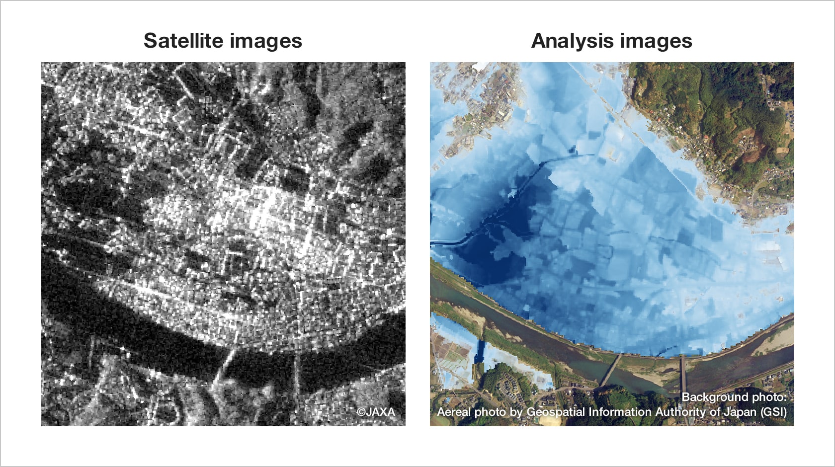
Radar satellites send monochrome images resembling the images of babies and organs captured by medical ultrasound scanners. These are difficult to figure out what is in the image. To solve this problem, Mitsubishi Electric’s satellite observation solution division processes images before providing customers with the data so that, for example, in flooding, the range of damage stands out, by coloring the affected areas, and overlaying the image over a map.
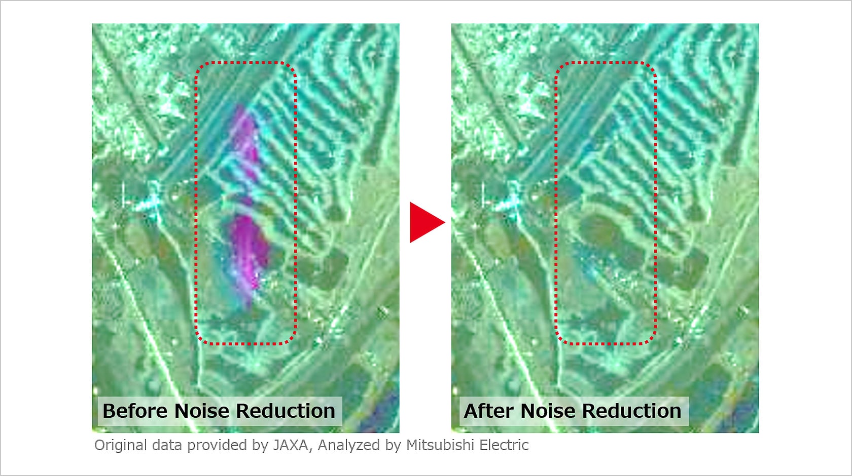
Sango: Mitsubishi Electric has acquired several patents regarding satellite image analysis treatment and processing. One of those is pertinent to "noise reduction." The images of land surface taken by radars are often affected by the interference of strong signals originated from urban areas. By removing those noises to make the original targets clear to see, this technology helps achieve more accurate analysis results of ground deformation monitoring.
Creating New Businesses Using Satellite Data
Mitsubishi Electric’s satellite observation solution related division has been receiving a number of inquiries from the financial sector, including banks and insurers, as well as electric power companies, which all previously had little to do with space or artificial satellites.
Sagara: For example, for their ESG investment (i.e., investing in companies conscious of environment and society and with good corporate governance), banks are considering using satellite data to ascertain the investment destination’s ESG credentials. We have already begun detailed discussions and examinations with banks as to how to utilize satellite data to solve social challenges.
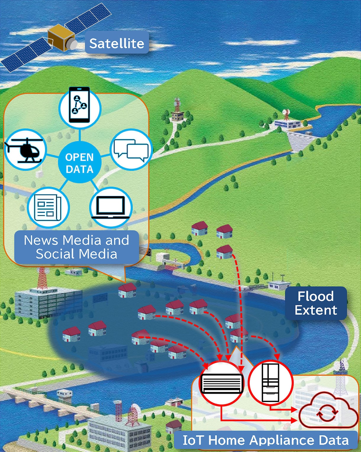
Mitsubishi Electric is also working to develop new products and services that utilize satellite data. One of those initiatives is linking with IoT home electrical appliances. For instance, when a home air conditioner’s external unit is submerged during flooding, signals are sent out to the manufacturer. By collecting these signals to compare with satellite data, flood damages can be assessed for a wider area and in more details.
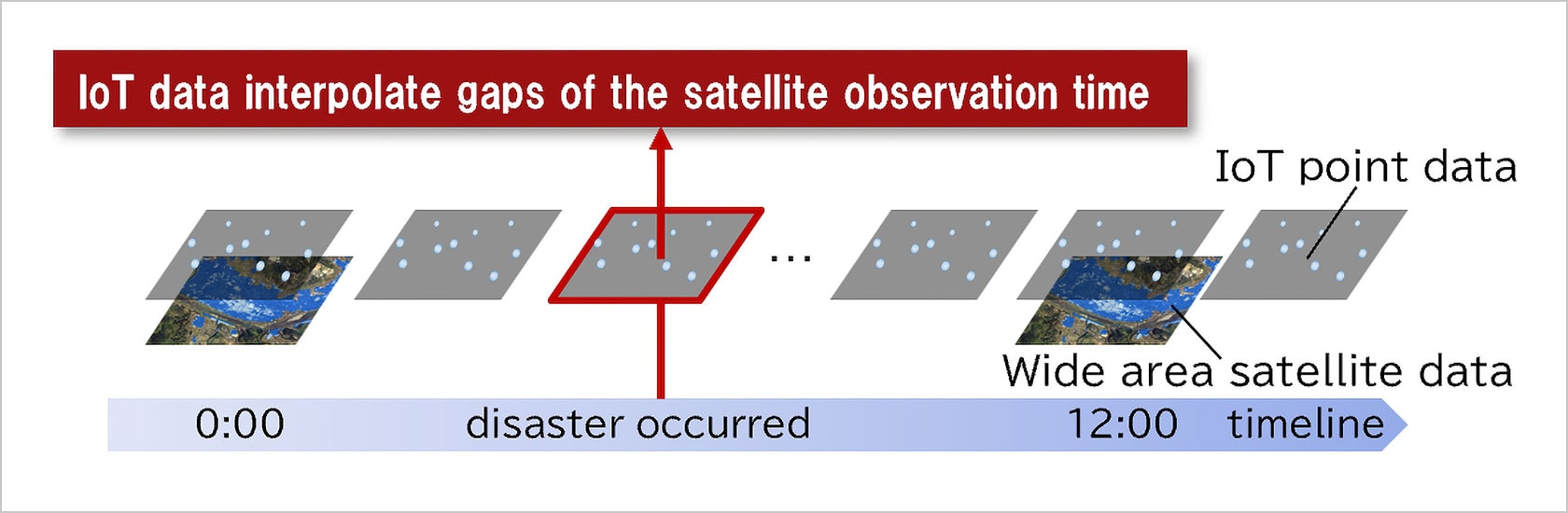

Satellite data can also be used for reconstruction plans following disasters. For instance, DAICHI-2’s observation data revealed that the ground had moved in some areas by as much as 9 cm in the year after the 2016 Kumamoto Earthquake. This type of information will help municipal governments to formulate more precise restoration plans, which, in turn, will help construction companies, insurers, and house owners to prepare better for rebuilding.
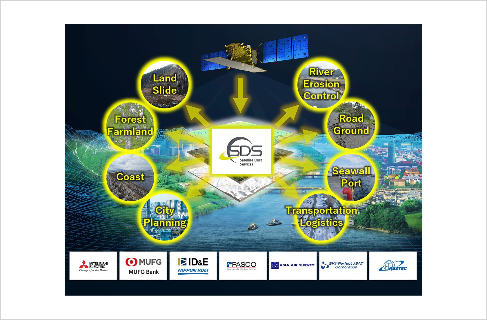
Establishing a Planning Company to Promote the Utilization of Satellite Data
In June 2021, Mitsubishi Electric jointly established Satellite Data Services Co., Ltd. (SDS) with ID&E Holdings, Pasco Corporation, Asia Air Survey Co., Ltd., SKY Perfect JSAT Holdings Inc, and Remote Sensing Technology Center of Japan (RESTEC). In February 2024, MUFG Bank, Ltd. Joined in investing in SDS shares. SDS is a start-up to promote the utilization of satellite data, by providing a wide range of users with satellite data analysis information. Mitsubishi Electric and SDS jointly applied for one of Japan’s Cabinet Office’s BRIDGE programs*3, the research and development call for "Construction, Operation, Demonstration, and Commercialization of the Japanese Version of the Disaster Charter*4," and were selected. In April 2024, SDS also applied with a smaller SAR satellite start-up, iQPS Inc., and other partners for an auxiliary project of the Small Business Innovation Research (SBIR) scheme implemented by Japan’s Ministry of Economy, Trade and Industry (METI) and was selected. The project will receive a grant amounting up to ¥330 million, aiming to achieve the establishment of flooding/landside damage support systems and road inspection support systems that utilize SAR satellite data by March 2028.
Additionally, MUFG Bank’s recent participation means that SDS will also pursue new possibilities for satellite data to be used for financial and economic activities, including the achievement of carbon neutrality and contribution to sustainable businesses.
- 3 Programs to promote innovative measures, including R&D activities implemented by Japanese ministries and government agencies, based on the policy to Promote Science, Technology, and Innovation Creation. The BRIDGE programs use the function of the Council for Science, Technology and Innovation (CSTI) as headquarters. By setting "key issues" (e.g., business environment enhancement, generation of start-ups, and human resources development, etc.), various initiatives are promoted, as well as R&D activities.
- 4 The International Disaster Charter is an agreement between space agencies and operators around the world to provide satellite data to assess the severity of damages and support relief efforts in the event of a disaster. As there is no scheme in place in Japan for satellite data to be used in the event of a disaster, an initiative led by the Cabinet Office is under way to establish the Japanese Version of Disaster Charter as a framework to enable the utilization of data, by gathering necessary satellite resources during a disaster.
Sagara: I have been involved in "making" satellites. For me, there will be no bigger motivation than to feel that satellites are useful to people’s lives and disaster prevention, when satellite observation solutions grow and spread. Now I am part of a solution development team, I am looking forward to finding innovative ways to utilize satellite data, while listening to what customers want.
Mitsubishi Electric has been developing and manufacturing artificial satellites and their on-board components for more than 70 years as Japan’s top maker. The company is now aiming at the top position in the realm of satellite observation solutions, working to develop businesses. It is interesting to see what type of new businesses Mitsubishi Electric will venture into and how it will support our lifestyles through partnerships with the public sector, companies from different industries, and start-ups.


